


2012-04-24 11h48m14

trailer.nono
User
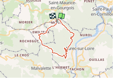

Length
12.6 km

Max alt
820 m

Uphill gradient
445 m
Km-Effort
18.6 km

Min alt
496 m

Downhill gradient
445 m
Boucle
Yes
Creation date :
2014-12-10 00:00:00.0
Updated on :
2014-12-10 00:00:00.0
1h26
Difficulty : Medium

FREE GPS app for hiking
 SityTrail
IGN / Geographical institutes
SityTrail Plus
The world is yours!
About
Trail Running of 12.6 km to be discovered at Auvergne-Rhône-Alpes, Haute-Loire, Aurec-sur-Loire. This trail is proposed by trailer.nono.
Positioning
Country:
France
Region :
Auvergne-Rhône-Alpes
Department/Province :
Haute-Loire
Municipality :
Aurec-sur-Loire
Location:
Unknown
Start:(Dec)
Start:(UTM)
592074 ; 5026899 (31T) N.
Comments