Trail Cycle Lons-le-Saunier - 20120428 ALL - Photo
 alexbnmr
alexbnmr

User

© OpenStreetMap contributors
Length
Length
80 km
Max alt
Max alt
611 m
Uphill gradient
Uphill gradient
1028 m
Km-Effort
Km-Effort  
94 km
Min alt
Min alt
225 m
Downhill gradient
Downhill gradient
1027 m
Boucle
Boucle
Yes
Creation date :
2014-12-10 00:00:00.0
Updated on :
2014-12-10 00:00:00.0

(0 Reviews)

Cycle
Cycle
--
Difficulty : Medium

Scan this QR Code to open this trail in the SityTrail application

FREE GPS app for hiking

Logo SityTrail SityTrail

IGN / Geographical institutes

Download SityTrail from the App Store Download SityTrail from Google Play

Logo SityTrail SityTrail Plus

The world is yours!

Download SityTrail from the App Store Download SityTrail from Google Play Download SityTrail on Huawei AppGallery

About

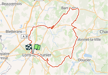
Trail Cycle of 80 km to be discovered at Bourgogne-Franche-Comté, Jura, Lons-le-Saunier. This trail is proposed by alexbnmr.

Description

LONS - L'ETOILE - QUINTIGNY - ARLAY - ST GERMAIN LES ARLAY DOMBLANS - VOITEUR - CHATEAU CHALON - PLASNE - BARRETAINE CHAMPVAUX - route foresti�re for�t de POLIGNY - LE FIED - PICARREAU - FAY EN MONTAGNE - BONNEFONTAINE - MIREBEL - CHATILLON - VERGES - PUBLY CONLIEGE - LON

Elevation profile

Points of interest

Point of interest Lons-le-Saunier - OR-1496349:20120428 long 80.039  - Photo
alexbnmr

Positioning

Country:
France
Region :
Bourgogne-Franche-Comté
Department/Province :
Jura
Municipality :
Lons-le-Saunier
Location:
Unknown
Start:(Dec)
Start:(UTM)
694491 ; 5172311 (31T) N.


Close
My subscriptions