


2012-04-27 23h25m09

alexbnmr
User
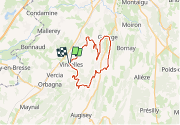

Length
27 km

Max alt
568 m

Uphill gradient
664 m
Km-Effort
35 km

Min alt
215 m

Downhill gradient
682 m
Boucle
Yes
Creation date :
2014-12-10 00:00:00.0
Updated on :
2014-12-10 00:00:00.0
2h29
Difficulty : Difficult

FREE GPS app for hiking
 SityTrail
IGN / Geographical institutes
SityTrail Plus
The world is yours!
About
Trail Mountain bike of 27 km to be discovered at Bourgogne-Franche-Comté, Jura, Val-Sonnette. This trail is proposed by alexbnmr.
Positioning
Country:
France
Region :
Bourgogne-Franche-Comté
Department/Province :
Jura
Municipality :
Val-Sonnette
Location:
Unknown
Start:(Dec)
Start:(UTM)
689782 ; 5163905 (31T) N.
Comments