Trail Mountain bike Mandeure - GTJ INTEGRALE - Photo
 DANCHAUD
DANCHAUD

User

© OpenStreetMap contributors
Length
Length
365 km
Max alt
Max alt
1351 m
Uphill gradient
Uphill gradient
9539 m
Km-Effort
Km-Effort  
490 km
Min alt
Min alt
335 m
Downhill gradient
Downhill gradient
8737 m
Boucle
Boucle
No
Creation date :
2014-12-10 00:00:00.0
Updated on :
2014-12-10 00:00:00.0

(0 Reviews)

Mountain bike
Mountain bike
--
Difficulty : Medium

Scan this QR Code to open this trail in the SityTrail application

FREE GPS app for hiking

Logo SityTrail SityTrail

IGN / Geographical institutes

Download SityTrail from the App Store Download SityTrail from Google Play

Logo SityTrail SityTrail Plus

The world is yours!

Download SityTrail from the App Store Download SityTrail from Google Play Download SityTrail on Huawei AppGallery

About

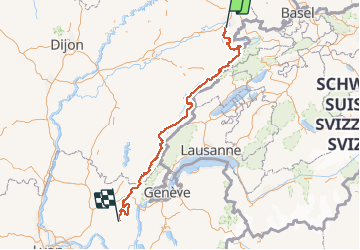
Trail Mountain bike of 365 km to be discovered at Bourgogne-Franche-Comté, Doubs, Mandeure. This trail is proposed by DANCHAUD.

Description

voici le tracé de la GTJ en version intégrale d’après le guide CHAMINA.La version light n'est pas tracé dans cette version.
ATTENTION LE D  N'EST PAS LE BON
car je n'ai pas calculer le D  avant la sauvegarde.

Elevation profile

Positioning

Country:
France
Region :
Bourgogne-Franche-Comté
Department/Province :
Doubs
Municipality :
Mandeure
Location:
Unknown
Start:(UTM)
334316 ; 5257505 (32T) N.


Close
My subscriptions