![](/images/other/stat-length.png)
![Trail Mountain bike Hières-sur-Amby - hyeres sur amby optevoz - Photo](https://media.geolcdn.com/t/1900/400/ext.pjpeg?maxdim=2&url=https%3A%2F%2Fservices.sitytrail.com%2FGeolivesWS%2FDownloadMedia.ashx%3FTrailID%3D124150%26Media%3D20120420170038.jpeg)
hyeres sur amby optevoz
marc6262
User
![Length](/images/other/stat-length.png)
Length
19.4 km
![Max alt](https://static1.geolcdn.com/siteimages/upload/files/1508320355ic_sort_altitude_max_24dp.png)
Max alt
393 m
![Uphill gradient](https://static1.geolcdn.com/siteimages/upload/files/1508320355ic_sort_den_pos_24dp.png)
Uphill gradient
403 m
![Km-Effort](/images/other/stat-length.png)
Km-Effort
25 km
![Min alt](https://static1.geolcdn.com/siteimages/upload/files/1508320355ic_sort_altitude_min_24dp.png)
Min alt
214 m
![Downhill gradient](https://static1.geolcdn.com/siteimages/upload/files/1508320355ic_sort_den_neg_24dp.png)
Downhill gradient
401 m
![Boucle](https://static1.geolcdn.com/siteimages/upload/files/16400158638029165_repeat_loop_refresh_sync_direction_icon.png)
Boucle
Yes
Creation date :
2014-12-10 00:00:00.0
Updated on :
2014-12-10 00:00:00.0
![Mountain bike](https://static1.geolcdn.com/sitytour/trail-icons/202.png)
2h26
Difficulty : Medium
![Scan this QR Code to open this trail in the SityTrail application](https://capi.geolives.com/qq0zvz2zws4bq2lad0pu/sitytour/trails/124150/qr.png?size=200)
FREE GPS app for hiking
About
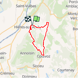
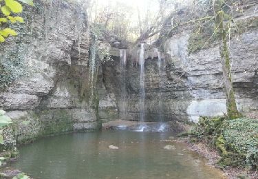
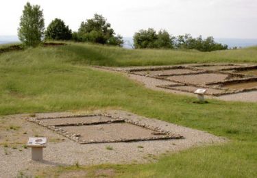
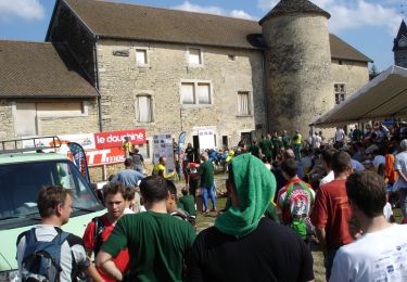
Trail Mountain bike of 19.4 km to be discovered at Auvergne-Rhône-Alpes, Isère, Hières-sur-Amby. This trail is proposed by marc6262.
Description
Grosse montée en poussant jusqu'à la madone - très beaux points de vue.
ensuite de la ballade puisune belle descente !
Attention aux enfants .... passages proches du vide
Positioning
Country:
France
Region :
Auvergne-Rhône-Alpes
Department/Province :
Isère
Municipality :
Hières-sur-Amby
Location:
Unknown
Start:(Dec)
Start:(UTM)
679055 ; 5074358 (31T) N.
Comments
Trails nearby
![Trail Walking Charette - Cascade de la Roche - Photo](https://media.geolcdn.com/t/375/260/ext.jpg?maxdim=2&url=https%3A%2F%2Fmedia.geolcdn.com%2Ff%2Fbd5860d1-f736-4991-9f48-e2dd903a6cda.jpg)
![Walking Walking](https://static1.geolcdn.com/sitytour/trail-icons/101.png)
Cascade de la Roche
Walking
Easy
Charette,
Auvergne-Rhône-Alpes,
Isère,
France
![](/images/other/stat-length.png)
9 km | 10.4 km-effort
2h 8min
![](https://static1.geolcdn.com/siteimages/upload/files/16400158638029165_repeat_loop_refresh_sync_direction_icon.png)
Yes
![Trail Walking Saint-Baudille-de-la-Tour - Et Baudille de la tour - Photo](https://media.geolcdn.com/t/375/260/ext.jpg?maxdim=2&url=https%3A%2F%2Fmedia.geolcdn.com%2Ff%2F8c1d4f66-36a8-4941-9217-61cdbcb28135.jpg)
![Walking Walking](https://static1.geolcdn.com/sitytour/trail-icons/101.png)
Et Baudille de la tour
Walking
Easy
Saint-Baudille-de-la-Tour,
Auvergne-Rhône-Alpes,
Isère,
France
![](/images/other/stat-length.png)
12 km | 14 km-effort
3h 11min
![](https://static1.geolcdn.com/siteimages/upload/files/16400158638029165_repeat_loop_refresh_sync_direction_icon.png)
Yes
![Trail Walking Hières-sur-Amby - Hieres sur Amby - Photo](https://media.geolcdn.com/t/375/260/ext.jpg?maxdim=2&url=https%3A%2F%2Fservices.sitytrail.com%2FGeolivesWS%2FDownloadMedia.ashx%3FTrailID%3D145103%26Media%3D20120809165504.jpeg)
![Walking Walking](https://static1.geolcdn.com/sitytour/trail-icons/101.png)
Hieres sur Amby
Walking
Medium
(1)
Hières-sur-Amby,
Auvergne-Rhône-Alpes,
Isère,
France
![](/images/other/stat-length.png)
14.4 km | 19.5 km-effort
4h 27min
![](https://static1.geolcdn.com/siteimages/upload/files/16400158638029165_repeat_loop_refresh_sync_direction_icon.png)
Yes
![Trail Mountain bike La Balme-les-Grottes - Joli tour cascade de la roche - Photo](https://media.geolcdn.com/t/375/260/ext.jpg?maxdim=2&url=https%3A%2F%2Fservices.sitytrail.com%2FGeolivesWS%2FDownloadMedia.ashx%3FTrailID%3D120784%26Media%3D20120409114131.jpeg)
![Mountain bike Mountain bike](https://static1.geolcdn.com/sitytour/trail-icons/202.png)
Joli tour cascade de la roche
Mountain bike
Medium
La Balme-les-Grottes,
Auvergne-Rhône-Alpes,
Isère,
France
![](/images/other/stat-length.png)
23 km | 28 km-effort
1h 59min
![](https://static1.geolcdn.com/siteimages/upload/files/16400158638029165_repeat_loop_refresh_sync_direction_icon.png)
Yes
![Trail Walking Charette - La Craz St Baudille - Photo](https://media.geolcdn.com/t/375/260/ext.jpg?maxdim=2&url=https%3A%2F%2Fmedia.geolcdn.com%2Ff%2F564ef5d0-46bc-4954-ac36-92b55ca71a9e.jpg)
![Walking Walking](https://static1.geolcdn.com/sitytour/trail-icons/101.png)
La Craz St Baudille
Walking
Easy
Charette,
Auvergne-Rhône-Alpes,
Isère,
France
![](/images/other/stat-length.png)
9 km | 11.5 km-effort
2h 39min
![](https://static1.geolcdn.com/siteimages/upload/files/16400158638029165_repeat_loop_refresh_sync_direction_icon.png)
Yes
![Trail Walking Saint-Vulbas - Saint vulbac - Photo](https://media.geolcdn.com/t/375/260/ext.jpg?maxdim=2&url=https%3A%2F%2Fmedia.geolcdn.com%2Ff%2F8e813a6b-739c-411a-99b4-e2cd7142bd40.jpg)
![Walking Walking](https://static1.geolcdn.com/sitytour/trail-icons/101.png)
Saint vulbac
Walking
Saint-Vulbas,
Auvergne-Rhône-Alpes,
Ain,
France
![](/images/other/stat-length.png)
11.3 km | 12.1 km-effort
59min
![](https://static1.geolcdn.com/siteimages/upload/files/16400158638029165_repeat_loop_refresh_sync_direction_icon.png)
No
![Trail Walking Optevoz - rando cascade de la roche - Photo](https://media.geolcdn.com/t/375/260/ext.jpg?maxdim=2&url=https%3A%2F%2Fservices.sitytrail.com%2FGeolivesWS%2FDownloadMedia.ashx%3FTrailID%3D463288%26Media%3Dfix__20141102141608.jpg)
![Walking Walking](https://static1.geolcdn.com/sitytour/trail-icons/101.png)
rando cascade de la roche
Walking
Easy
Optevoz,
Auvergne-Rhône-Alpes,
Isère,
France
![](/images/other/stat-length.png)
16.2 km | 19.2 km-effort
4h 36min
![](https://static1.geolcdn.com/siteimages/upload/files/16400158638029165_repeat_loop_refresh_sync_direction_icon.png)
Yes
![Trail Walking Annoisin-Chatelans - De Chatelans à Larina - Photo](https://media.geolcdn.com/t/375/260/ext.jpg?maxdim=2&url=https%3A%2F%2Fservices.sitytrail.com%2FGeolivesWS%2FDownloadMedia.ashx%3FTrailID%3D106700%26Media%3D11338_1.jpg)
![Walking Walking](https://static1.geolcdn.com/sitytour/trail-icons/101.png)
De Chatelans à Larina
Walking
Medium
Annoisin-Chatelans,
Auvergne-Rhône-Alpes,
Isère,
France
![](/images/other/stat-length.png)
6.9 km | 9.8 km-effort
2h 0min
![](https://static1.geolcdn.com/siteimages/upload/files/16400158638029165_repeat_loop_refresh_sync_direction_icon.png)
Yes
![Trail Mountain bike Saint-Baudille-de-la-Tour - Rando VTT Nord Isère 45 km - Photo](https://media.geolcdn.com/t/375/260/ext.jpg?maxdim=2&url=https%3A%2F%2Fservices.sitytrail.com%2FGeolivesWS%2FDownloadMedia.ashx%3FTrailID%3D101627%26Media%3D1810_1.jpg)
![Mountain bike Mountain bike](https://static1.geolcdn.com/sitytour/trail-icons/202.png)
Rando VTT Nord Isère 45 km
Mountain bike
Very difficult
Saint-Baudille-de-la-Tour,
Auvergne-Rhône-Alpes,
Isère,
France
![](/images/other/stat-length.png)
46 km | 60 km-effort
3h 30min
![](https://static1.geolcdn.com/siteimages/upload/files/16400158638029165_repeat_loop_refresh_sync_direction_icon.png)
Yes