


2012-04-29 19h47m39

Jeff_314
User
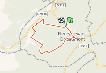

Length
6.8 km

Max alt
352 m

Uphill gradient
159 m
Km-Effort
9 km

Min alt
251 m

Downhill gradient
165 m
Boucle
Yes
Creation date :
2014-12-10 00:00:00.0
Updated on :
2014-12-10 00:00:00.0
1h53
Difficulty : Medium

FREE GPS app for hiking
 SityTrail
IGN / Geographical institutes
SityTrail Plus
The world is yours!
About
Trail Walking of 6.8 km to be discovered at Grand Est, Meuse, Fleury-devant-Douaumont. This trail is proposed by Jeff_314.
Positioning
Country:
France
Region :
Grand Est
Department/Province :
Meuse
Municipality :
Fleury-devant-Douaumont
Location:
Unknown
Start:(Dec)
Start:(UTM)
676965 ; 5452336 (31U) N.
Comments