


Tarquimpol - Lindre Basse

MMarie
User
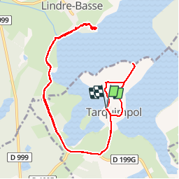

Length
13.3 km

Max alt
237 m

Uphill gradient
151 m
Km-Effort
15.3 km

Min alt
207 m

Downhill gradient
150 m
Boucle
Yes
Creation date :
2014-12-10 00:00:00.0
Updated on :
2014-12-10 00:00:00.0
3h30
Difficulty : Easy

FREE GPS app for hiking
 SityTrail
IGN / Geographical institutes
SityTrail Plus
The world is yours!
About
Trail Walking of 13.3 km to be discovered at Grand Est, Moselle, Tarquimpol. This trail is proposed by MMarie.
Description
Balade ornithologique


Positioning
Country:
France
Region :
Grand Est
Department/Province :
Moselle
Municipality :
Tarquimpol
Location:
Unknown
Start:(Dec)
Start:(UTM)
335184 ; 5406066 (32U) N.
Comments