


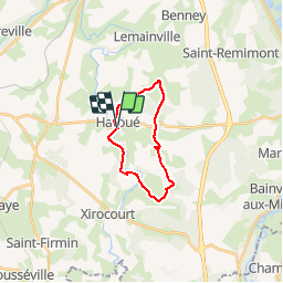
Pays d'Haroué

MMarie
User

Length
15.3 km

Max alt
329 m

Uphill gradient
226 m
Km-Effort
18.3 km

Min alt
237 m

Downhill gradient
226 m
Boucle
Yes
Creation date :
2014-12-10 00:00:00.0
Updated on :
2014-12-10 00:00:00.0
4h05
Difficulty : Medium

FREE GPS app for hiking
 SityTrail
IGN / Geographical institutes
SityTrail Plus
The world is yours!
About
Trail Walking of 15.3 km to be discovered at Grand Est, Meurthe-et-Moselle, Haroué. This trail is proposed by MMarie.
Description
Haroué - Ormes et Villes - Vaudeville - Vaudigny -Haroué
TopoGuide 7 La Lorraine à pied
Michel&Carmen 13/05/2012
Positioning
Country:
France
Region :
Grand Est
Department/Province :
Meurthe-et-Moselle
Municipality :
Haroué
Location:
Unknown
Start:(Dec)
Start:(UTM)
291504 ; 5372052 (32U) N.
Comments