Trail Walking Auvers - Le mont Mouchet 2012-05-16 - Photo

Le mont Mouchet 2012-05-16

© OpenStreetMap contributors
Length
Length
6.8 km
Max alt
Max alt
1494 m
Uphill gradient
Uphill gradient
188 m
Km-Effort
Km-Effort  
9.3 km
Min alt
Min alt
1314 m
Downhill gradient
Downhill gradient
194 m
Boucle
Boucle
Yes
Creation date :
2014-12-10 00:00:00.0
Updated on :
2014-12-10 00:00:00.0

(0 Reviews)

Walking
Walking
1h59
Difficulty : Easy

Scan this QR Code to open this trail in the SityTrail application

FREE GPS app for hiking

Logo SityTrail SityTrail

IGN / Geographical institutes

Download SityTrail from the App Store Download SityTrail from Google Play

Logo SityTrail SityTrail World

The world is yours!

Download SityTrail from the App Store Download SityTrail from Google Play Download SityTrail on Huawei AppGallery

About

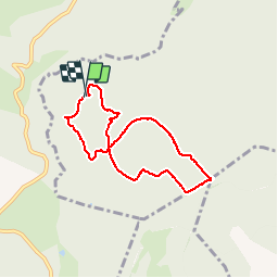
Trail Walking of 6.8 km to be discovered at Auvergne-Rhône-Alpes, Haute-Loire, Auvers. This trail is proposed by gerard1222.

Description

Rando au mont Mouchet à partir du mémorial et du musée de la résistance

Elevation profile

Positioning

Country:
France
Region :
Auvergne-Rhône-Alpes
Department/Province :
Haute-Loire
Municipality :
Auvers
Location:
Unknown
Start:(UTM)
527811 ; 4981338 (31T) N.

Trails nearby

Trail On foot Paulhac-en-Margeride - La Molle - Photo
On foot
guitounette

On foot

Easy
(2)
Paulhac-en-Margeride, Occitania, Lozère, France
8.5 km | 12 km-effort
2h 42min
Yes
Trail Mountain bike Clavières - GTMC de Claire - 5 - Photo
Mountain bike
tracegps

Mountain bike

Very difficult
Clavières, Auvergne-Rhône-Alpes, Cantal, France
64 km | 83 km-effort
4h 49min
No
Trail Walking Paulhac-en-Margeride - Tour du mont Mouchet - Photo
Walking
pgeiger

Walking

Very easy
Paulhac-en-Margeride, Occitania, Lozère, France
10.5 km | 14.4 km-effort
5h 2min
Yes
Trail Mountain bike Clavières - GTMC J5 - Photo
Mountain bike
PhilippeC54

Mountain bike

Medium
Clavières, Auvergne-Rhône-Alpes, Cantal, France
37 km | 51 km-effort
3h 17min
No
Trail Other activity Auvers - buis - Photo
Other activity
adribio

Other activity

Very easy
Auvers, Auvergne-Rhône-Alpes, Haute-Loire, France
21 km | 35 km-effort
3h 35min
No
Trail Moto cross Paulhac-en-Margeride - paulhac en margeride/brioude 5jours 2024 - Photo
Moto cross
frank12

Moto cross

Easy
(1)
Paulhac-en-Margeride, Occitania, Lozère, France
91 km | 131 km-effort
Unknown
No
Trail Moto cross Paulhac-en-Margeride - paulhac en margeride/brioude 5jours 2024 version 2 - Photo
Moto cross
frank12

Moto cross

Easy
Paulhac-en-Margeride, Occitania, Lozère, France
116 km | 167 km-effort
Unknown
No
Trail Walking Paulhac-en-Margeride - Paulhac en Margeride - Photo
Walking
boyer43

Walking

Very difficult
Paulhac-en-Margeride, Occitania, Lozère, France
27 km | 38 km-effort
8h 42min
Yes
Trail Walking La Besseyre-Saint-Mary - la besseyre st marie - Photo
Walking
boyer43

Walking

Very difficult
La Besseyre-Saint-Mary, Auvergne-Rhône-Alpes, Haute-Loire, France
24 km | 35 km-effort
7h 51min
Yes


Close
My subscriptions