![](/images/other/stat-length.png)
![Trail Walking Lechâtelet - Sentier Dame Renaude - Lechâtelet - Photo](https://media.geolcdn.com/t/1900/400/ext.pjpeg?maxdim=2&url=https%3A%2F%2Fservices.sitytrail.com%2FGeolivesWS%2FDownloadMedia.ashx%3FTrailID%3D129809%26Media%3D13358_6.jpg)
Sentier Dame Renaude - Lechâtelet
tracegps
User
![Length](/images/other/stat-length.png)
Length
10.3 km
![Max alt](https://static1.geolcdn.com/siteimages/upload/files/1508320355ic_sort_altitude_max_24dp.png)
Max alt
184 m
![Uphill gradient](https://static1.geolcdn.com/siteimages/upload/files/1508320355ic_sort_den_pos_24dp.png)
Uphill gradient
55 m
![Km-Effort](/images/other/stat-length.png)
Km-Effort
11 km
![Min alt](https://static1.geolcdn.com/siteimages/upload/files/1508320355ic_sort_altitude_min_24dp.png)
Min alt
170 m
![Downhill gradient](https://static1.geolcdn.com/siteimages/upload/files/1508320355ic_sort_den_neg_24dp.png)
Downhill gradient
50 m
![Boucle](https://static1.geolcdn.com/siteimages/upload/files/16400158638029165_repeat_loop_refresh_sync_direction_icon.png)
Boucle
Yes
Creation date :
2014-12-10 00:00:00.0
Updated on :
2014-12-10 00:00:00.0
![Walking](https://static1.geolcdn.com/sitytour/trail-icons/101.png)
3h00
Difficulty : Medium
![Scan this QR Code to open this trail in the SityTrail application](https://capi.geolives.com/qq0zvz2zws4bq2lad0pu/sitytour/trails/129809/qr.png?size=200)
FREE GPS app for hiking
About
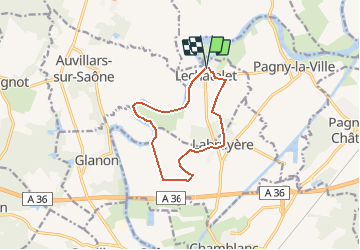
Trail Walking of 10.3 km to be discovered at Bourgogne-Franche-Comté, Côte-d'Or, Lechâtelet. This trail is proposed by tracegps.
Description
Circuit que nous avons fait du départ de l'église du village Lechâtelet où on prend le balisage jaune. Circuit très facile, plat tout le long. Une partie en bord de la vieille Saône. Attention, balisage absent quand on sort du village de Labruyère à travers champs.
Positioning
Country:
France
Region :
Bourgogne-Franche-Comté
Department/Province :
Côte-d'Or
Municipality :
Lechâtelet
Location:
Unknown
Start:(Dec)
Start:(UTM)
662809 ; 5214219 (31T) N.
Comments
Trails nearby
![Trail Walking Brochon - falaises et plateau - Photo](https://media.geolcdn.com/t/375/260/ext.jpg?maxdim=2&url=https%3A%2F%2Fservices.sitytrail.com%2FGeolivesWS%2FDownloadMedia.ashx%3FTrailID%3D640375%26Media%3Dfix__20161002163015.jpg)
![Walking Walking](https://static1.geolcdn.com/sitytour/trail-icons/101.png)
falaises et plateau
Walking
Difficult
(1)
Brochon,
Bourgogne-Franche-Comté,
Côte-d'Or,
France
![](/images/other/stat-length.png)
15.9 km | 22 km-effort
4h 45min
![](https://static1.geolcdn.com/siteimages/upload/files/16400158638029165_repeat_loop_refresh_sync_direction_icon.png)
No
![Trail On foot Vougeot - Circuit des Moines (Vin - Divin) - Photo](https://media.geolcdn.com/t/375/260/ext.jpg?maxdim=2&url=https%3A%2F%2Fmedia.geolcdn.com%2Ff%2Ffb87caa2-4087-4afb-9662-94262f347d38.jpeg)
![On foot On foot](https://static1.geolcdn.com/sitytour/trail-icons/100.png)
Circuit des Moines (Vin - Divin)
On foot
Easy
Vougeot,
Bourgogne-Franche-Comté,
Côte-d'Or,
France
![](/images/other/stat-length.png)
15.7 km | 17.4 km-effort
3h 56min
![](https://static1.geolcdn.com/siteimages/upload/files/16400158638029165_repeat_loop_refresh_sync_direction_icon.png)
No
![Trail Mountain bike Curley - raidetoto2017 sam - Photo](https://media.geolcdn.com/t/375/260/ext.jpg?maxdim=2&url=https%3A%2F%2Fstatic1.geolcdn.com%2Fsiteimages%2Fupload%2Ffiles%2F1524743154velo.jpg)
![Mountain bike Mountain bike](https://static1.geolcdn.com/sitytour/trail-icons/202.png)
raidetoto2017 sam
Mountain bike
Difficult
(1)
Curley,
Bourgogne-Franche-Comté,
Côte-d'Or,
France
![](/images/other/stat-length.png)
67 km | 88 km-effort
7h 2min
![](https://static1.geolcdn.com/siteimages/upload/files/16400158638029165_repeat_loop_refresh_sync_direction_icon.png)
Yes
![Trail Walking Brochon - Boucle des cent marches et du pavillon de l'empereur - Photo](https://media.geolcdn.com/t/375/260/ext.jpg?maxdim=2&url=https%3A%2F%2Fmedia.geolcdn.com%2Ff%2Fc945b0b3-6e82-40bf-bac2-b1d204cc41d7.jpg)
![Walking Walking](https://static1.geolcdn.com/sitytour/trail-icons/101.png)
Boucle des cent marches et du pavillon de l'empereur
Walking
Medium
Brochon,
Bourgogne-Franche-Comté,
Côte-d'Or,
France
![](/images/other/stat-length.png)
5.5 km | 8.1 km-effort
1h 38min
![](https://static1.geolcdn.com/siteimages/upload/files/16400158638029165_repeat_loop_refresh_sync_direction_icon.png)
Yes
![Trail Walking Curtil-Vergy - Abbaye saint Vivant - Photo](https://media.geolcdn.com/t/375/260/ext.jpg?maxdim=2&url=https%3A%2F%2Fmedia.geolcdn.com%2Ff%2F040e75f6-3ed9-4472-88f3-28e2fffd2eca.jpg)
![Walking Walking](https://static1.geolcdn.com/sitytour/trail-icons/101.png)
Abbaye saint Vivant
Walking
Curtil-Vergy,
Bourgogne-Franche-Comté,
Côte-d'Or,
France
![](/images/other/stat-length.png)
10 km | 14.3 km-effort
2h 43min
![](https://static1.geolcdn.com/siteimages/upload/files/16400158638029165_repeat_loop_refresh_sync_direction_icon.png)
No
![Trail Walking Vougeot - Autour de Clos Vougeot - Photo](https://media.geolcdn.com/t/375/260/ext.jpg?maxdim=2&url=https%3A%2F%2Fmedia.geolcdn.com%2Ff%2Fe8418b80-584d-474a-873b-a50634ac31f8.jpg)
![Walking Walking](https://static1.geolcdn.com/sitytour/trail-icons/101.png)
Autour de Clos Vougeot
Walking
Very easy
Vougeot,
Bourgogne-Franche-Comté,
Côte-d'Or,
France
![](/images/other/stat-length.png)
11.2 km | 14.2 km-effort
3h 3min
![](https://static1.geolcdn.com/siteimages/upload/files/16400158638029165_repeat_loop_refresh_sync_direction_icon.png)
No
![Trail Walking Chambolle-Musigny - 08 06 22 Chambolle Musigny Gevrey Chambertin - Photo](https://media.geolcdn.com/t/375/260/ext.jpg?maxdim=2&url=https%3A%2F%2Fmedia.geolcdn.com%2Ff%2F86837a5a-a630-409a-9571-da8b3289e82a.jpg)
![Walking Walking](https://static1.geolcdn.com/sitytour/trail-icons/101.png)
08 06 22 Chambolle Musigny Gevrey Chambertin
Walking
Medium
Chambolle-Musigny,
Bourgogne-Franche-Comté,
Côte-d'Or,
France
![](/images/other/stat-length.png)
14.3 km | 19.1 km-effort
4h 47min
![](https://static1.geolcdn.com/siteimages/upload/files/16400158638029165_repeat_loop_refresh_sync_direction_icon.png)
Yes
![Trail Walking Vougeot - Clos Vougeot - Photo](https://media.geolcdn.com/t/375/260/ext.jpg?maxdim=2&url=https%3A%2F%2Fmedia.geolcdn.com%2Ff%2F8843a1f8-c482-480f-894d-54c94bee14d2.jpg)
![Walking Walking](https://static1.geolcdn.com/sitytour/trail-icons/101.png)
Clos Vougeot
Walking
Medium
Vougeot,
Bourgogne-Franche-Comté,
Côte-d'Or,
France
![](/images/other/stat-length.png)
16 km | 21 km-effort
4h 26min
![](https://static1.geolcdn.com/siteimages/upload/files/16400158638029165_repeat_loop_refresh_sync_direction_icon.png)
Yes
![Trail On foot Gevrey-Chambertin - Sentier Bernard Quarteaux - Photo](https://media.geolcdn.com/t/375/260/ext.jpg?maxdim=2&url=https%3A%2F%2Fmedia.geolcdn.com%2Ff%2F841522af-1ea0-428a-9257-df0e01d41583.jpeg)
![On foot On foot](https://static1.geolcdn.com/sitytour/trail-icons/100.png)
Sentier Bernard Quarteaux
On foot
Easy
Gevrey-Chambertin,
Bourgogne-Franche-Comté,
Côte-d'Or,
France
![](/images/other/stat-length.png)
6.4 km | 9.5 km-effort
2h 10min
![](https://static1.geolcdn.com/siteimages/upload/files/16400158638029165_repeat_loop_refresh_sync_direction_icon.png)
Yes