
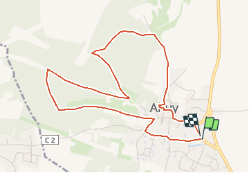
Circuit du Four à Chaux - Ahuy

tracegps
User

Length
5.4 km

Max alt
360 m

Uphill gradient
115 m
Km-Effort
6.9 km

Min alt
273 m

Downhill gradient
114 m
Boucle
Yes
Creation date :
2014-12-10 00:00:00.0
Updated on :
2014-12-10 00:00:00.0
2h00
Difficulty : Easy

FREE GPS app for hiking
 SityTrail
IGN / Geographical institutes
SityTrail Plus
The world is yours!
About
Trail Walking of 5.4 km to be discovered at Bourgogne-Franche-Comté, Côte-d'Or, Ahuy. This trail is proposed by tracegps.
Description
Départ place du 19 mars 1962. Balisage pas très bien suivi.
Photos


Positioning
Country:
France
Region :
Bourgogne-Franche-Comté
Department/Province :
Côte-d'Or
Municipality :
Ahuy
Location:
Unknown
Start:(Dec)
Start:(UTM)
652836 ; 5248004 (31T) N.
Comments