


Vittel - la Neuville - Vittel

MMarie
User
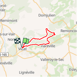

Length
17.7 km

Max alt
473 m

Uphill gradient
283 m
Km-Effort
22 km

Min alt
334 m

Downhill gradient
283 m
Boucle
Yes
Creation date :
2014-12-10 00:00:00.0
Updated on :
2014-12-10 00:00:00.0
4h44
Difficulty : Difficult

FREE GPS app for hiking
 SityTrail
IGN / Geographical institutes
SityTrail Plus
The world is yours!
About
Trail Walking of 17.7 km to be discovered at Grand Est, Vosges, Vittel. This trail is proposed by MMarie.
Description
Randonnée 32
Topo Guide La Lorraine à pied
Michel & Carmen
27/05/2012
Positioning
Country:
France
Region :
Grand Est
Department/Province :
Vosges
Municipality :
Vittel
Location:
Unknown
Start:(Dec)
Start:(UTM)
718522 ; 5343176 (31U) N.
Comments