


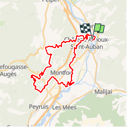
La Jarlandine 35 km - 2012-05-27

ja.13061965
User

Length
40 km

Max alt
657 m

Uphill gradient
920 m
Km-Effort
52 km

Min alt
411 m

Downhill gradient
919 m
Boucle
Yes
Creation date :
2019-06-20 09:33:49.75
Updated on :
2019-06-20 09:33:52.558
5h46
Difficulty : Difficult

FREE GPS app for hiking
 SityTrail
IGN / Geographical institutes
SityTrail Plus
The world is yours!
About
Trail Mountain bike of 40 km to be discovered at Provence-Alpes-Côte d'Azur, Alpes-de-Haute-Provence, Château-Arnoux-Saint-Auban. This trail is proposed by ja.13061965.
Positioning
Country:
France
Region :
Provence-Alpes-Côte d'Azur
Department/Province :
Alpes-de-Haute-Provence
Municipality :
Château-Arnoux-Saint-Auban
Location:
Unknown
Start:(Dec)
Start:(UTM)
261136 ; 4886948 (32T) N.
Comments