


Trail Hillion 2012

philoustetou
User

Length
14.7 km

Max alt
60 m

Uphill gradient
222 m
Km-Effort
17.7 km

Min alt
2 m

Downhill gradient
223 m
Boucle
Yes
Creation date :
2014-12-10 00:00:00.0
Updated on :
2014-12-10 00:00:00.0
1h05
Difficulty : Medium

FREE GPS app for hiking
 SityTrail
IGN / Geographical institutes
SityTrail Plus
The world is yours!
About
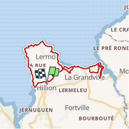
Trail Running of 14.7 km to be discovered at Brittany, Côtes-d'Armor, Hillion. This trail is proposed by philoustetou.
Description
(Boucle) Départ au terrain des sports. Superbe tracé, très varié empruntant le sentier des douaniers, vue imprenable sur la baie de St Brieuc. 90' pour un coureur moyen. Compter 3h en rando.
Positioning
Country:
France
Region :
Brittany
Department/Province :
Côtes-d'Armor
Municipality :
Hillion
Location:
Unknown
Start:(Dec)
Start:(UTM)
524603 ; 5373821 (30U) N.
Comments