![](/images/other/stat-length.png)
![Trail Running Hillion - Trail Hillion 2012 - Photo](https://media.geolcdn.com/t/1900/400/ext.pjpeg?maxdim=2&url=https%3A%2F%2Fstatic1.geolcdn.com%2Fsiteimages%2Fupload%2Ffiles%2F1524743154running.jpg)
Trail Hillion 2012
philoustetou
User
![Length](/images/other/stat-length.png)
Length
14.7 km
![Max alt](https://static1.geolcdn.com/siteimages/upload/files/1508320355ic_sort_altitude_max_24dp.png)
Max alt
60 m
![Uphill gradient](https://static1.geolcdn.com/siteimages/upload/files/1508320355ic_sort_den_pos_24dp.png)
Uphill gradient
222 m
![Km-Effort](/images/other/stat-length.png)
Km-Effort
17.7 km
![Min alt](https://static1.geolcdn.com/siteimages/upload/files/1508320355ic_sort_altitude_min_24dp.png)
Min alt
2 m
![Downhill gradient](https://static1.geolcdn.com/siteimages/upload/files/1508320355ic_sort_den_neg_24dp.png)
Downhill gradient
223 m
![Boucle](https://static1.geolcdn.com/siteimages/upload/files/16400158638029165_repeat_loop_refresh_sync_direction_icon.png)
Boucle
Yes
Creation date :
2014-12-10 00:00:00.0
Updated on :
2014-12-10 00:00:00.0
![Running](https://static1.geolcdn.com/sitytour/trail-icons/103.png)
1h05
Difficulty : Medium
![Scan this QR Code to open this trail in the SityTrail application](https://capi.geolives.com/qq0zvz2zws4bq2lad0pu/sitytour/trails/130809/qr.png?size=200)
FREE GPS app for hiking
About
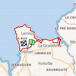
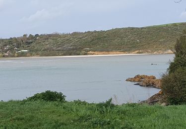
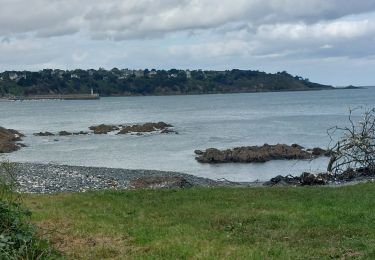
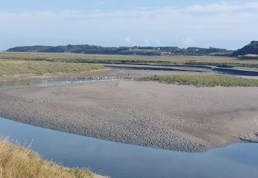
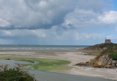
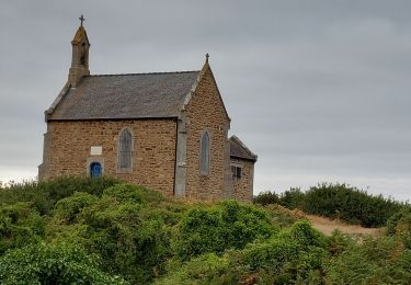
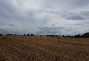
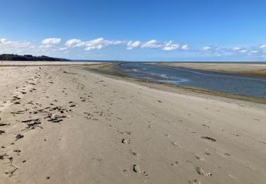
Trail Running of 14.7 km to be discovered at Brittany, Côtes-d'Armor, Hillion. This trail is proposed by philoustetou.
Description
(Boucle) Départ au terrain des sports. Superbe tracé, très varié empruntant le sentier des douaniers, vue imprenable sur la baie de St Brieuc. 90' pour un coureur moyen. Compter 3h en rando.
Positioning
Country:
France
Region :
Brittany
Department/Province :
Côtes-d'Armor
Municipality :
Hillion
Location:
Unknown
Start:(Dec)
Start:(UTM)
524603 ; 5373821 (30U) N.
Comments
Trails nearby
![Trail Walking Plérin - Martin plage vers St. brieuc - Photo](https://media.geolcdn.com/t/375/260/ext.jpg?maxdim=2&url=https%3A%2F%2Fservices.sitytrail.com%2FGeolivesWS%2FDownloadMedia.ashx%3FTrailID%3D46956%26Media%3Dimage2.jpg)
![Walking Walking](https://static1.geolcdn.com/sitytour/trail-icons/101.png)
Martin plage vers St. brieuc
Walking
Very easy
(1)
Plérin,
Brittany,
Côtes-d'Armor,
France
![](/images/other/stat-length.png)
2.4 km | 2.9 km-effort
Unknown
![](https://static1.geolcdn.com/siteimages/upload/files/16400158638029165_repeat_loop_refresh_sync_direction_icon.png)
No
![Trail Walking Hillion - Hillion - Photo](https://media.geolcdn.com/t/375/260/ext.jpg?maxdim=2&url=https%3A%2F%2Fmedia.geolcdn.com%2Ff%2F5f86b00a-294e-442a-9394-58fb975dda85.jpg)
![Walking Walking](https://static1.geolcdn.com/sitytour/trail-icons/101.png)
Hillion
Walking
Medium
Hillion,
Brittany,
Côtes-d'Armor,
France
![](/images/other/stat-length.png)
10.3 km | 12.3 km-effort
2h 47min
![](https://static1.geolcdn.com/siteimages/upload/files/16400158638029165_repeat_loop_refresh_sync_direction_icon.png)
Yes
![Trail Walking Plérin - GR_34_CD_17_Plerin_Binic-Etables-Sur-Mer_20230924 - Photo](https://media.geolcdn.com/t/375/260/ext.jpg?maxdim=2&url=https%3A%2F%2Fmedia.geolcdn.com%2Ff%2F36e1f8fb-a9cf-4b3d-b99c-e80bd83817cc.jpg)
![Walking Walking](https://static1.geolcdn.com/sitytour/trail-icons/101.png)
GR_34_CD_17_Plerin_Binic-Etables-Sur-Mer_20230924
Walking
Medium
Plérin,
Brittany,
Côtes-d'Armor,
France
![](/images/other/stat-length.png)
12.9 km | 17.3 km-effort
3h 32min
![](https://static1.geolcdn.com/siteimages/upload/files/16400158638029165_repeat_loop_refresh_sync_direction_icon.png)
No
![Trail Walking Yffiniac - GR_34_CC_16_Yffiniac_Plerin_20230923 - Photo](https://media.geolcdn.com/t/375/260/ext.jpg?maxdim=2&url=https%3A%2F%2Fmedia.geolcdn.com%2Ff%2Ff34d56e4-fc23-400a-bbb5-8ed0508632bd.jpg)
![Walking Walking](https://static1.geolcdn.com/sitytour/trail-icons/101.png)
GR_34_CC_16_Yffiniac_Plerin_20230923
Walking
Easy
Yffiniac,
Brittany,
Côtes-d'Armor,
France
![](/images/other/stat-length.png)
16.2 km | 19.5 km-effort
3h 47min
![](https://static1.geolcdn.com/siteimages/upload/files/16400158638029165_repeat_loop_refresh_sync_direction_icon.png)
No
![Trail Walking Lamballe-Armor - GR_34_CB_15_Lamballe_Yffiniac_20230922 - Photo](https://media.geolcdn.com/t/375/260/ext.jpg?maxdim=2&url=https%3A%2F%2Fmedia.geolcdn.com%2Ff%2F95482d3b-17df-46c8-b98d-a214b5d07890.jpg)
![Walking Walking](https://static1.geolcdn.com/sitytour/trail-icons/101.png)
GR_34_CB_15_Lamballe_Yffiniac_20230922
Walking
Very difficult
Lamballe-Armor,
Brittany,
Côtes-d'Armor,
France
![](/images/other/stat-length.png)
17 km | 20 km-effort
4h 38min
![](https://static1.geolcdn.com/siteimages/upload/files/16400158638029165_repeat_loop_refresh_sync_direction_icon.png)
No
![Trail Walking Lamballe-Armor - LES PONTS NEUFS DEPUIS LA CHAPELLE SAINT-MAURICE - Photo](https://media.geolcdn.com/t/375/260/ext.jpg?maxdim=2&url=https%3A%2F%2Fmedia.geolcdn.com%2Ff%2F50217cef-5adc-4fcb-b707-2ba68b727565.jpg)
![Walking Walking](https://static1.geolcdn.com/sitytour/trail-icons/101.png)
LES PONTS NEUFS DEPUIS LA CHAPELLE SAINT-MAURICE
Walking
Difficult
Lamballe-Armor,
Brittany,
Côtes-d'Armor,
France
![](/images/other/stat-length.png)
11.4 km | 14.4 km-effort
3h 10min
![](https://static1.geolcdn.com/siteimages/upload/files/16400158638029165_repeat_loop_refresh_sync_direction_icon.png)
Yes
![Trail Walking Saint-Brieuc - Douvenant-Gréves des courses - Photo](https://media.geolcdn.com/t/375/260/ext.jpg?maxdim=2&url=https%3A%2F%2Fmedia.geolcdn.com%2Ff%2F8be6c264-f66c-4426-a3ec-7921fbb42659.jpg)
![Walking Walking](https://static1.geolcdn.com/sitytour/trail-icons/101.png)
Douvenant-Gréves des courses
Walking
Very easy
Saint-Brieuc,
Brittany,
Côtes-d'Armor,
France
![](/images/other/stat-length.png)
10.4 km | 12.5 km-effort
2h 18min
![](https://static1.geolcdn.com/siteimages/upload/files/16400158638029165_repeat_loop_refresh_sync_direction_icon.png)
Yes
![Trail Walking Lamballe-Armor - Hillion, Les ponts neufs, Grd tour - Photo](https://media.geolcdn.com/t/375/260/ext.jpg?maxdim=2&url=https%3A%2F%2Fmedia.geolcdn.com%2Ff%2Fd6f9ac0c-bbb0-4e95-985e-ffd718b35a44.jpg)
![Walking Walking](https://static1.geolcdn.com/sitytour/trail-icons/101.png)
Hillion, Les ponts neufs, Grd tour
Walking
Easy
Lamballe-Armor,
Brittany,
Côtes-d'Armor,
France
![](/images/other/stat-length.png)
9.6 km | 11.1 km-effort
2h 55min
![](https://static1.geolcdn.com/siteimages/upload/files/16400158638029165_repeat_loop_refresh_sync_direction_icon.png)
Yes
![Trail Walking Hillion - Chemin Cotier - Photo](https://media.geolcdn.com/t/375/260/ext.jpg?maxdim=2&url=https%3A%2F%2Fmedia.geolcdn.com%2Ff%2F42f526c4-934a-4376-a446-a8c6058ebcae.jpg)
![Walking Walking](https://static1.geolcdn.com/sitytour/trail-icons/101.png)
Chemin Cotier
Walking
Medium
Hillion,
Brittany,
Côtes-d'Armor,
France
![](/images/other/stat-length.png)
12 km | 14.2 km-effort
3h 21min
![](https://static1.geolcdn.com/siteimages/upload/files/16400158638029165_repeat_loop_refresh_sync_direction_icon.png)
Yes