


2012-05-29 13h35m05

Jeff_314
User
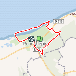

Length
6.6 km

Max alt
119 m

Uphill gradient
122 m
Km-Effort
8.2 km

Min alt
0 m

Downhill gradient
122 m
Boucle
Yes
Creation date :
2014-12-10 00:00:00.0
Updated on :
2014-12-10 00:00:00.0
2h10
Difficulty : Easy

FREE GPS app for hiking
 SityTrail
IGN / Geographical institutes
SityTrail Plus
The world is yours!
About
Trail Walking of 6.6 km to be discovered at Normandy, Calvados, Pennedepie. This trail is proposed by Jeff_314.
Positioning
Country:
France
Region :
Normandy
Department/Province :
Calvados
Municipality :
Pennedepie
Location:
Unknown
Start:(Dec)
Start:(UTM)
295262 ; 5476530 (31U) N.
Comments
Circuit tranquile entre bois et mer pour agrémenter un beau we de juillet. Belle escale au domaine d'Apreval proche de l'arrivée.