


2012-06-09 16h57m11

alexbnmr
User
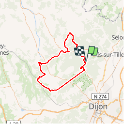

Length
94 km

Max alt
565 m

Uphill gradient
1568 m
Km-Effort
115 km

Min alt
320 m

Downhill gradient
1568 m
Boucle
Yes
Creation date :
2014-12-10 00:00:00.0
Updated on :
2014-12-10 00:00:00.0
5h30
Difficulty : Medium

FREE GPS app for hiking
 SityTrail
IGN / Geographical institutes
SityTrail Plus
The world is yours!
About
Trail Cycle of 94 km to be discovered at Bourgogne-Franche-Comté, Côte-d'Or, Vernot. This trail is proposed by alexbnmr.
Positioning
Country:
France
Region :
Bourgogne-Franche-Comté
Department/Province :
Côte-d'Or
Municipality :
Vernot
Location:
Unknown
Start:(Dec)
Start:(UTM)
648709 ; 5261880 (31T) N.
Comments