


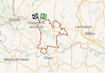
la ronde des bois du vexin

medhy60
User

Length
58 km

Max alt
152 m

Uphill gradient
592 m
Km-Effort
66 km

Min alt
61 m

Downhill gradient
592 m
Boucle
Yes
Creation date :
2014-12-10 00:00:00.0
Updated on :
2014-12-10 00:00:00.0
3h19
Difficulty : Medium

FREE GPS app for hiking
 SityTrail
IGN / Geographical institutes
SityTrail Plus
The world is yours!
About
Trail Mountain bike of 58 km to be discovered at Hauts-de-France, Oise, Chaumont-en-Vexin. This trail is proposed by medhy60.
Positioning
Country:
France
Region :
Hauts-de-France
Department/Province :
Oise
Municipality :
Chaumont-en-Vexin
Location:
Unknown
Start:(Dec)
Start:(UTM)
419649 ; 5457877 (31U) N.
Comments