


Génicourt sur Meuse

MMarie
User
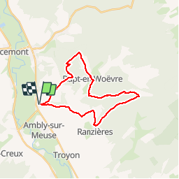

Length
24 km

Max alt
371 m

Uphill gradient
460 m
Km-Effort
30 km

Min alt
220 m

Downhill gradient
461 m
Boucle
Yes
Creation date :
2014-12-10 00:00:00.0
Updated on :
2014-12-10 00:00:00.0
6h27
Difficulty : Difficult

FREE GPS app for hiking
 SityTrail
IGN / Geographical institutes
SityTrail Plus
The world is yours!
About
Trail Walking of 24 km to be discovered at Grand Est, Meuse, Génicourt-sur-Meuse. This trail is proposed by MMarie.
Description
Les 3 Monts
Rando Numéro 15, TopoGuide La Lorraine à pied
A noter pour la vue de mammifères sauvages et le magnifique panorama final.
Michel & Carmen
24 juin 2012
Positioning
Country:
France
Region :
Grand Est
Department/Province :
Meuse
Municipality :
Génicourt-sur-Meuse
Location:
Unknown
Start:(Dec)
Start:(UTM)
678223 ; 5434340 (31U) N.
Comments