


TREGARVAN_6,7km_Trace GPS

Pousscailleux
User
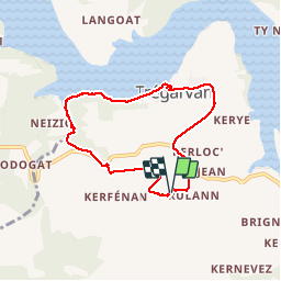

Length
6.7 km

Max alt
86 m

Uphill gradient
133 m
Km-Effort
8.4 km

Min alt
-1 m

Downhill gradient
132 m
Boucle
Yes
Creation date :
2014-12-10 00:00:00.0
Updated on :
2014-12-10 00:00:00.0
1h50
Difficulty : Easy

FREE GPS app for hiking
 SityTrail
IGN / Geographical institutes
SityTrail Plus
The world is yours!
About
Trail Walking of 6.7 km to be discovered at Brittany, Finistère, Trégarvan. This trail is proposed by Pousscailleux.
Description
Départ du centre de vacances de KerBeuz;
Positioning
Country:
France
Region :
Brittany
Department/Province :
Finistère
Municipality :
Trégarvan
Location:
Unknown
Start:(Dec)
Start:(UTM)
408911 ; 5343777 (30U) N.
Comments
Jolies vies sur l'Aulne, promenade agréable en sous-bois mais très boueux par endroits. La fin de parcours à travers champs n'a pas été possible (chemin désormais entravé), il faut contourner par la route (+ 15').