


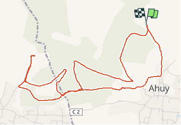
Circuit du four

eprf
User

Length
7.3 km

Max alt
382 m

Uphill gradient
139 m
Km-Effort
9.2 km

Min alt
303 m

Downhill gradient
140 m
Boucle
Yes
Creation date :
2014-12-10 00:00:00.0
Updated on :
2014-12-10 00:00:00.0
50m
Difficulty : Medium

FREE GPS app for hiking
 SityTrail
IGN / Geographical institutes
SityTrail Plus
The world is yours!
About
Trail Running of 7.3 km to be discovered at Bourgogne-Franche-Comté, Côte-d'Or, Ahuy. This trail is proposed by eprf.
Description
Attention, petite partie "escalade"
Positioning
Country:
France
Region :
Bourgogne-Franche-Comté
Department/Province :
Côte-d'Or
Municipality :
Ahuy
Location:
Unknown
Start:(Dec)
Start:(UTM)
652280 ; 5249110 (31T) N.
Comments