


velo meon

bena42
User

Length
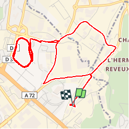
33 km

Max alt
519 m

Uphill gradient
334 m
Km-Effort
38 km

Min alt
490 m

Downhill gradient
337 m
Boucle
Yes
Creation date :
2014-12-10 00:00:00.0
Updated on :
2014-12-10 00:00:00.0
1h14
Difficulty : Very easy

FREE GPS app for hiking
 SityTrail
IGN / Geographical institutes
SityTrail Plus
The world is yours!
About
Trail Cycle of 33 km to be discovered at Auvergne-Rhône-Alpes, Loire, Saint-Étienne. This trail is proposed by bena42.
Description
16 07 12
Positioning
Country:
France
Region :
Auvergne-Rhône-Alpes
Department/Province :
Loire
Municipality :
Saint-Étienne
Location:
Unknown
Start:(Dec)
Start:(UTM)
611022 ; 5034391 (31T) N.
Comments