


Langon N°4

durmord
User
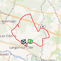

Length
15 km

Max alt
135 m

Uphill gradient
92 m
Km-Effort
16.3 km

Min alt
115 m

Downhill gradient
92 m
Boucle
Yes
Creation date :
2019-04-28 13:04:32.393
Updated on :
2019-04-28 13:04:32.426
--
Difficulty : Easy

FREE GPS app for hiking
 SityTrail
IGN / Geographical institutes
SityTrail Plus
The world is yours!
About
Trail Cycle of 15 km to be discovered at Centre-Loire Valley, Loir-et-Cher, Langon-sur-Cher. This trail is proposed by durmord.
Positioning
Country:
France
Region :
Centre-Loire Valley
Department/Province :
Loir-et-Cher
Municipality :
Langon-sur-Cher
Location:
Unknown
Start:(Dec)
Start:(UTM)
411902 ; 5237416 (31T) N.
Comments