


2012-07-27 Rando le Chemin de Bernières

jchezlemas
User
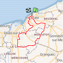

Length
13.1 km

Max alt
139 m

Uphill gradient
252 m
Km-Effort
16.4 km

Min alt
2 m

Downhill gradient
252 m
Boucle
Yes
Creation date :
2014-12-10 00:00:00.0
Updated on :
2014-12-10 00:00:00.0
3h14
Difficulty : Medium

FREE GPS app for hiking
 SityTrail
IGN / Geographical institutes
SityTrail Plus
The world is yours!
About
Trail Walking of 13.1 km to be discovered at Normandy, Calvados, Houlgate. This trail is proposed by jchezlemas.
Positioning
Country:
France
Region :
Normandy
Department/Province :
Calvados
Municipality :
Houlgate
Location:
Unknown
Start:(Dec)
Start:(UTM)
712606 ; 5465199 (30U) N.
Comments