


Belos à Belos

philoustetou
User
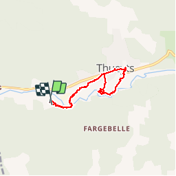


1h26
Difficulty : Medium

FREE GPS app for hiking
 SityTrail
IGN / Geographical institutes
SityTrail Plus
The world is yours!
About
Trail Walking of 5.7 km to be discovered at Auvergne-Rhône-Alpes, Ardèche, Thueyts. This trail is proposed by philoustetou.
Description
En partant du camping de Belos ou de Thueyts, l'escalier de la Reine, le pont du diable et l'échelle du Roi, une cassure dans le basalte assez difficile pour les personnes sujettes au vertige.
Photos


Positioning
Comments