


parc de sceaux

guariso
User
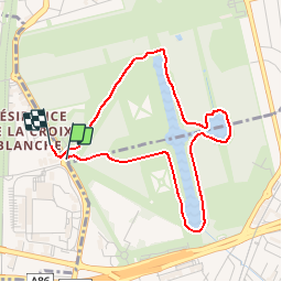

Length
3.8 km

Max alt
77 m

Uphill gradient
37 m
Km-Effort
4.3 km

Min alt
53 m

Downhill gradient
35 m
Boucle
Yes
Creation date :
2014-12-10 00:00:00.0
Updated on :
2014-12-10 00:00:00.0
15m
Difficulty : Very easy

FREE GPS app for hiking
 SityTrail
IGN / Geographical institutes
SityTrail Plus
The world is yours!
About
Trail Cycle of 3.8 km to be discovered at Ile-de-France, Hauts-de-Seine, Sceaux. This trail is proposed by guariso.
Description
Petite balade autour des plans d'eau
Positioning
Country:
France
Region :
Ile-de-France
Department/Province :
Hauts-de-Seine
Municipality :
Sceaux
Location:
Unknown
Start:(Dec)
Start:(UTM)
447844 ; 5401783 (31U) N.
Comments