


crv005-camping_comblain-la-tour_boucle_via_ourthe_fairon_5.4km

tilto
User
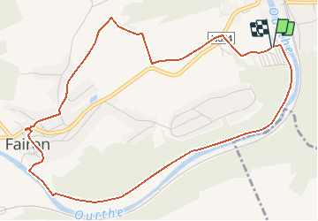

Length
5.4 km

Max alt
167 m

Uphill gradient
86 m
Km-Effort
6.5 km

Min alt
104 m

Downhill gradient
81 m
Boucle
Yes
Creation date :
2014-12-10 00:00:00.0
Updated on :
2014-12-10 00:00:00.0
1h28
Difficulty : Easy

FREE GPS app for hiking
 SityTrail
IGN / Geographical institutes
SityTrail Plus
The world is yours!
About
Trail Walking of 5.4 km to be discovered at Wallonia, Liège, Hamoir. This trail is proposed by tilto.
Description
Boucle : départ cafétaria Départ "Camping Le Rocher de la Vierge" à Comblain-la-tour (Hamoir). Le charme du bord d'Outhe, petit chemin à Comblain-fairon, direction le Soleil et retour par chemins bucoliques
Positioning
Country:
Belgium
Region :
Wallonia
Department/Province :
Liège
Municipality :
Hamoir
Location:
Comblain-Fairon
Start:(Dec)
Start:(UTM)
682219 ; 5591969 (31U) N.
Comments