


Stevenson étape 3

MMarie
User
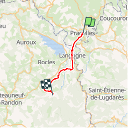

Length
24 km

Max alt
1236 m

Uphill gradient
504 m
Km-Effort
31 km

Min alt
899 m

Downhill gradient
523 m
Boucle
No
Creation date :
2014-12-10 00:00:00.0
Updated on :
2014-12-10 00:00:00.0
6h45
Difficulty : Difficult

FREE GPS app for hiking
 SityTrail
IGN / Geographical institutes
SityTrail Plus
The world is yours!
About
Trail Walking of 24 km to be discovered at Auvergne-Rhône-Alpes, Haute-Loire, Pradelles. This trail is proposed by MMarie.
Description
Pradelles à Cheylard l'évêque
18/07/2012
Michel & Carmen
Positioning
Country:
France
Region :
Auvergne-Rhône-Alpes
Department/Province :
Haute-Loire
Municipality :
Pradelles
Location:
Unknown
Start:(Dec)
Start:(UTM)
570118 ; 4957623 (31T) N.
Comments