


andra 23-8-2012 44km

guariso
User

Length
45 km

Max alt
184 m

Uphill gradient
650 m
Km-Effort
53 km

Min alt
41 m

Downhill gradient
654 m
Boucle
Yes
Creation date :
2014-12-10 00:00:00.0
Updated on :
2014-12-10 00:00:00.0
4h17
Difficulty : Medium

FREE GPS app for hiking
 SityTrail
IGN / Geographical institutes
SityTrail Plus
The world is yours!
About
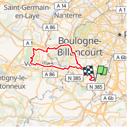
Trail Mountain bike of 45 km to be discovered at Ile-de-France, Hauts-de-Seine, Châtenay-Malabry. This trail is proposed by guariso.
Description
Ballade à vélo alternant ville (routes et pistes cyclables) et parcs ou forets.
Photos


Positioning
Country:
France
Region :
Ile-de-France
Department/Province :
Hauts-de-Seine
Municipality :
Châtenay-Malabry
Location:
Unknown
Start:(Dec)
Start:(UTM)
447461 ; 5402254 (31U) N.
Comments