


TÊTE de PRAOZELLE-1

RD78-38
User
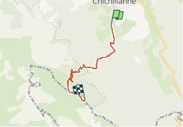

Length
9 km

Max alt
1692 m

Uphill gradient
694 m
Km-Effort
16.4 km

Min alt
1078 m

Downhill gradient
124 m
Boucle
No
Creation date :
2014-12-10 00:00:00.0
Updated on :
2020-07-11 00:26:03.857
3h37
Difficulty : Easy

FREE GPS app for hiking
 SityTrail
IGN / Geographical institutes
SityTrail Plus
The world is yours!
About
Trail Walking of 9 km to be discovered at Auvergne-Rhône-Alpes, Isère, Chichilianne. This trail is proposed by RD78-38.
Positioning
Country:
France
Region :
Auvergne-Rhône-Alpes
Department/Province :
Isère
Municipality :
Chichilianne
Location:
Unknown
Start:(Dec)
Start:(UTM)
703435 ; 4964556 (31T) N.
Comments