


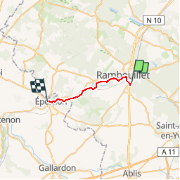
004 Rambouillet Epernon

lucille
User

Length
15.8 km

Max alt
174 m

Uphill gradient
163 m
Km-Effort
18.1 km

Min alt
114 m

Downhill gradient
214 m
Boucle
No
Creation date :
2014-12-10 00:00:00.0
Updated on :
2014-12-10 00:00:00.0
3h56
Difficulty : Unknown

FREE GPS app for hiking
 SityTrail
IGN / Geographical institutes
SityTrail Plus
The world is yours!
About
Trail Walking of 15.8 km to be discovered at Ile-de-France, Yvelines, Rambouillet. This trail is proposed by lucille.
Description
Rambouillet / Epernon Prieuré Saint Thomas
Positioning
Country:
France
Region :
Ile-de-France
Department/Province :
Yvelines
Municipality :
Rambouillet
Location:
Unknown
Start:(Dec)
Start:(UTM)
414233 ; 5387460 (31U) N.
Comments