


Cheverny-Chaumont 2

leeho
User
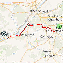

Length
29 km

Max alt
118 m

Uphill gradient
278 m
Km-Effort
33 km

Min alt
60 m

Downhill gradient
263 m
Boucle
No
Creation date :
2014-12-10 00:00:00.0
Updated on :
2014-12-10 00:00:00.0
1h30
Difficulty : Easy

FREE GPS app for hiking
 SityTrail
IGN / Geographical institutes
SityTrail Plus
The world is yours!
About
Trail Cycle of 29 km to be discovered at Centre-Loire Valley, Loir-et-Cher, Cour-Cheverny. This trail is proposed by leeho.
Description
De Cour-Cheverny à Chaumont-sur-Loire en passant par Beauregard. Itinéraire proposé en 2 par "Le Vélo voyageur"


Positioning
Country:
France
Region :
Centre-Loire Valley
Department/Province :
Loir-et-Cher
Municipality :
Cour-Cheverny
Location:
Unknown
Start:(Dec)
Start:(UTM)
383844 ; 5262708 (31T) N.
Comments