


Au Pays d'Azay-le-Rideau

leeho
User
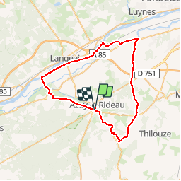

Length
53 km

Max alt
110 m

Uphill gradient
420 m
Km-Effort
58 km

Min alt
34 m

Downhill gradient
420 m
Boucle
No
Creation date :
2014-12-10 00:00:00.0
Updated on :
2014-12-10 00:00:00.0
2h40
Difficulty : Easy

FREE GPS app for hiking
 SityTrail
IGN / Geographical institutes
SityTrail Plus
The world is yours!
About
Trail Cycle of 53 km to be discovered at Centre-Loire Valley, Indre-et-Loire, Cheillé. This trail is proposed by leeho.
Description
Balade en les châteaux et la Loire
Positioning
Country:
France
Region :
Centre-Loire Valley
Department/Province :
Indre-et-Loire
Municipality :
Cheillé
Location:
Unknown
Start:(Dec)
Start:(UTM)
308176 ; 5237082 (31T) N.
Comments
