


villenauxe été 2012

Tollard
User
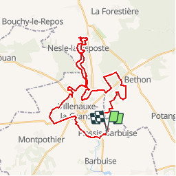

Length
35 km

Max alt
203 m

Uphill gradient
655 m
Km-Effort
43 km

Min alt
69 m

Downhill gradient
651 m
Boucle
Yes
Creation date :
2014-12-10 00:00:00.0
Updated on :
2014-12-10 00:00:00.0
--
Difficulty : Unknown

FREE GPS app for hiking
 SityTrail
IGN / Geographical institutes
SityTrail Plus
The world is yours!
About
Trail Mountain bike of 35 km to be discovered at Grand Est, Aube, Plessis-Barbuise. This trail is proposed by Tollard.
Positioning
Country:
France
Region :
Grand Est
Department/Province :
Aube
Municipality :
Plessis-Barbuise
Location:
Unknown
Start:(Dec)
Start:(UTM)
543073 ; 5380544 (31U) N.
Comments