Trail Walking Moret-Loing-et-Orvanne - 120919-GLM - Moret-ObservatSorques  - Photo

120919-GLM - Moret-ObservatSorques

 randodan
randodan

User

© OpenStreetMap contributors
Length
Length
12.2 km
Max alt
Max alt
102 m
Uphill gradient
Uphill gradient
134 m
Km-Effort
Km-Effort  
14 km
Min alt
Min alt
46 m
Downhill gradient
Downhill gradient
133 m
Boucle
Boucle
Yes
Creation date :
2014-12-10 00:00:00.0
Updated on :
2014-12-10 00:00:00.0

(0 Reviews)

Walking
Walking
3h31
Difficulty : Very easy

Scan this QR Code to open this trail in the SityTrail application

FREE GPS app for hiking

Logo SityTrail SityTrail

IGN / Geographical institutes

Download SityTrail from the App Store Download SityTrail from Google Play

Logo SityTrail SityTrail Plus

The world is yours!

Download SityTrail from the App Store Download SityTrail from Google Play Download SityTrail on Huawei AppGallery

About

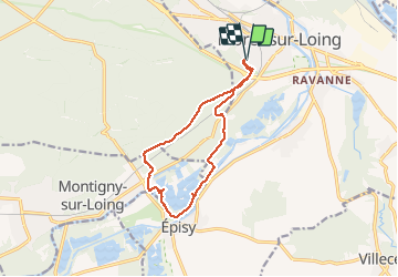
Trail Walking of 12.2 km to be discovered at Ile-de-France, Seine-et-Marne, Moret-Loing-et-Orvanne. This trail is proposed by randodan.

Description

Mercredi matin . JC propose les oiseaux de Sorques . Il ne se doutait pas de la belle figure qu'il allait nous faire faire . Une belle tête de lutin avec son bonnet flottant au vent, voici notre circuit ; son pompon resté accroché à Moret et croquant l'observatoire de Sorques !
5 participants .

Elevation profile

Photos

Points of interest

Point of interest Montigny-sur-Loing - Baignade interdite - Photo
randodan
MONTIGNY-SUR-LOING 

Positioning

Country:
France
Region :
Ile-de-France
Department/Province :
Seine-et-Marne
Municipality :
Moret-Loing-et-Orvanne
Location:
Moret-sur-Loing
Start:(UTM)
485641 ; 5357254 (31U) N.


Close
My subscriptions