


velo ostende 2012

eventstrail
User
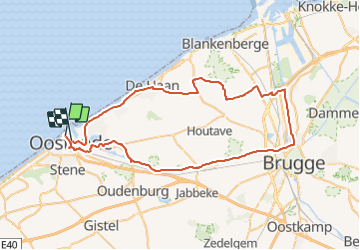

Length
62 km

Max alt
23 m

Uphill gradient
270 m
Km-Effort
66 km

Min alt
-4 m

Downhill gradient
276 m
Boucle
No
Creation date :
2014-12-10 00:00:00.0
Updated on :
2014-12-10 00:00:00.0
--
Difficulty : Medium

FREE GPS app for hiking
 SityTrail
IGN / Geographical institutes
SityTrail Plus
The world is yours!
About
Trail Other activity of 62 km to be discovered at Flanders, West Flanders, Ostend. This trail is proposed by eventstrail.
Positioning
Country:
Belgium
Region :
Flanders
Department/Province :
West Flanders
Municipality :
Ostend
Location:
Oostende
Start:(Dec)
Start:(UTM)
493890 ; 5675543 (31U) N.
Comments