


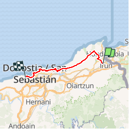
042 Irun Saint Sebastien

lucille
User

Length
25 km

Max alt
537 m

Uphill gradient
963 m
Km-Effort
38 km

Min alt
-4 m

Downhill gradient
959 m
Boucle
No
Creation date :
2014-12-10 00:00:00.0
Updated on :
2014-12-10 00:00:00.0
7h56
Difficulty : Unknown

FREE GPS app for hiking
 SityTrail
IGN / Geographical institutes
SityTrail Plus
The world is yours!
About
Trail Walking of 25 km to be discovered at Autonomous Community of the Basque Country, Gipuzkoa, Irun. This trail is proposed by lucille.
Description
Irun / Saint Sébastien
Ondarreta-La Sirena
Positioning
Country:
Spain
Region :
Autonomous Community of the Basque Country
Department/Province :
Gipuzkoa
Municipality :
Irun
Location:
Unknown
Start:(Dec)
Start:(UTM)
597398 ; 4799547 (30T) N.
Comments