


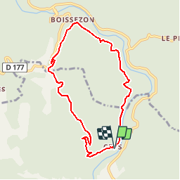
L'Ayrolle

CANON2
User

Length
8.1 km

Max alt
303 m

Uphill gradient
315 m
Km-Effort
12.3 km

Min alt
95 m

Downhill gradient
311 m
Boucle
Yes
Creation date :
2019-05-15 13:11:43.184
Updated on :
2019-05-15 13:11:43.222
2h50
Difficulty : Unknown

FREE GPS app for hiking
 SityTrail
IGN / Geographical institutes
SityTrail Plus
The world is yours!
About
Trail Walking of 8.1 km to be discovered at Occitania, Hérault, Roquebrun. This trail is proposed by CANON2.
Positioning
Country:
France
Region :
Occitania
Department/Province :
Hérault
Municipality :
Roquebrun
Location:
Unknown
Start:(Dec)
Start:(UTM)
499183 ; 4817806 (31T) N.
Comments