


FIALESSUCH

CANON2
User
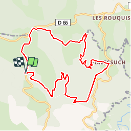

Length
11 km

Max alt
458 m

Uphill gradient
392 m
Km-Effort
16.2 km

Min alt
279 m

Downhill gradient
393 m
Boucle
Yes
Creation date :
2019-05-15 13:11:41.09
Updated on :
2019-05-15 13:11:41.165
3h29
Difficulty : Easy

FREE GPS app for hiking
 SityTrail
IGN / Geographical institutes
SityTrail Plus
The world is yours!
About
Trail Walking of 11 km to be discovered at Occitania, Tarn, Noailhac. This trail is proposed by CANON2.
Positioning
Country:
France
Region :
Occitania
Department/Province :
Tarn
Municipality :
Noailhac
Location:
Unknown
Start:(Dec)
Start:(UTM)
447253 ; 4826553 (31T) N.
Comments
charmante randonnee. A faire a partir de fin mars : nature plus verdoyante. Agreable aussi debut mars malgre le temps couvert et le vent d'autan !!!!