


LA QUILLE DU ROY

CANON2
User

Length
14.4 km

Max alt
512 m

Uphill gradient
383 m
Km-Effort
19.5 km

Min alt
228 m

Downhill gradient
378 m
Boucle
Yes
Creation date :
2019-05-15 13:11:40.668
Updated on :
2019-05-15 13:11:40.753
6h25
Difficulty : Medium

FREE GPS app for hiking
 SityTrail
IGN / Geographical institutes
SityTrail Plus
The world is yours!
About
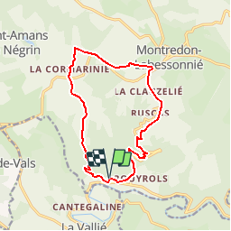
Trail Walking of 14.4 km to be discovered at Occitania, Tarn, Montredon-Labessonnié. This trail is proposed by CANON2.
Positioning
Country:
France
Region :
Occitania
Department/Province :
Tarn
Municipality :
Montredon-Labessonnié
Location:
Unknown
Start:(Dec)
Start:(UTM)
443857 ; 4837226 (31T) N.
Comments
facile