


LE CAMBAJOU

CANON2
User
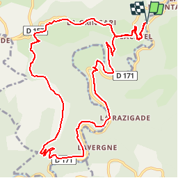

Length
13.9 km

Max alt
637 m

Uphill gradient
441 m
Km-Effort
19.8 km

Min alt
393 m

Downhill gradient
442 m
Boucle
Yes
Creation date :
2019-05-15 13:11:39.41
Updated on :
2019-05-15 13:11:39.452
4h21
Difficulty : Medium

FREE GPS app for hiking
 SityTrail
IGN / Geographical institutes
SityTrail Plus
The world is yours!
About
Trail Walking of 13.9 km to be discovered at Occitania, Tarn, Lacaze. This trail is proposed by CANON2.
Positioning
Country:
France
Region :
Occitania
Department/Province :
Tarn
Municipality :
Lacaze
Location:
Unknown
Start:(Dec)
Start:(UTM)
457658 ; 4842890 (31T) N.
Comments