


LES RIVIERALS

CANON2
User
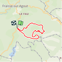

Length
11.1 km

Max alt
1085 m

Uphill gradient
215 m
Km-Effort
14 km

Min alt
992 m

Downhill gradient
213 m
Boucle
Yes
Creation date :
2019-05-15 13:11:37.761
Updated on :
2019-05-15 13:11:37.799
3h01
Difficulty : Very easy

FREE GPS app for hiking
 SityTrail
IGN / Geographical institutes
SityTrail Plus
The world is yours!
About
Trail Walking of 11.1 km to be discovered at Occitania, Hérault, Fraisse-sur-Agout. This trail is proposed by CANON2.
Positioning
Country:
France
Region :
Occitania
Department/Province :
Hérault
Municipality :
Fraisse-sur-Agout
Location:
Unknown
Start:(Dec)
Start:(UTM)
484030 ; 4825540 (31T) N.
Comments