


MALVIES

CANON2
User
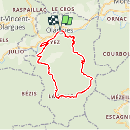

Length
14.1 km

Max alt
632 m

Uphill gradient
587 m
Km-Effort
22 km

Min alt
176 m

Downhill gradient
590 m
Boucle
Yes
Creation date :
2019-05-15 13:11:36.893
Updated on :
2019-05-15 13:11:36.956
4h41
Difficulty : Medium

FREE GPS app for hiking
 SityTrail
IGN / Geographical institutes
SityTrail Plus
The world is yours!
About
Trail Walking of 14.1 km to be discovered at Occitania, Hérault, Olargues. This trail is proposed by CANON2.
Positioning
Country:
France
Region :
Occitania
Department/Province :
Hérault
Municipality :
Olargues
Location:
Unknown
Start:(Dec)
Start:(UTM)
493054 ; 4822546 (31T) N.
Comments
Hérault olargued