


L'HOULETTE

CANON2
User
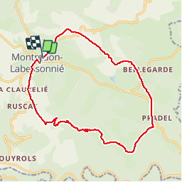

Length
17.5 km

Max alt
643 m

Uphill gradient
471 m
Km-Effort
24 km

Min alt
318 m

Downhill gradient
467 m
Boucle
No
Creation date :
2019-05-15 13:11:33.649
Updated on :
2019-05-15 13:11:33.761
5h01
Difficulty : Medium

FREE GPS app for hiking
 SityTrail
IGN / Geographical institutes
SityTrail Plus
The world is yours!
About
Trail Walking of 17.5 km to be discovered at Occitania, Tarn, Montredon-Labessonnié. This trail is proposed by CANON2.


Positioning
Country:
France
Region :
Occitania
Department/Province :
Tarn
Municipality :
Montredon-Labessonnié
Location:
Unknown
Start:(Dec)
Start:(UTM)
445848 ; 4840907 (31T) N.
Comments