


S-J-GIMONT - AUCH

CANON2
User
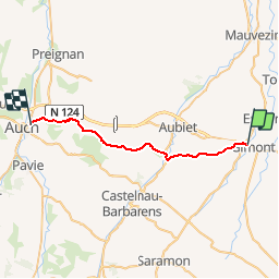

Length
27 km

Max alt
249 m

Uphill gradient
524 m
Km-Effort
34 km

Min alt
139 m

Downhill gradient
532 m
Boucle
No
Creation date :
2019-05-15 13:11:28.92
Updated on :
2019-05-15 13:11:28.966
6h20
Difficulty : Medium

FREE GPS app for hiking
 SityTrail
IGN / Geographical institutes
SityTrail Plus
The world is yours!
About
Trail Walking of 27 km to be discovered at Occitania, Gers, Gimont. This trail is proposed by CANON2.
Positioning
Country:
France
Region :
Occitania
Department/Province :
Gers
Municipality :
Gimont
Location:
Unknown
Start:(Dec)
Start:(UTM)
328220 ; 4832943 (31T) N.
Comments