


S-J-LODEVE-JONCEL

CANON2
User
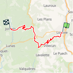

Length
23 km

Max alt
705 m

Uphill gradient
832 m
Km-Effort
33 km

Min alt
163 m

Downhill gradient
615 m
Boucle
No
Creation date :
2019-05-15 13:11:26.185
Updated on :
2019-05-15 13:11:26.266
7h05
Difficulty : Very difficult

FREE GPS app for hiking
 SityTrail
IGN / Geographical institutes
SityTrail Plus
The world is yours!
About
Trail Walking of 23 km to be discovered at Occitania, Hérault, Lodève. This trail is proposed by CANON2.
Positioning
Country:
France
Region :
Occitania
Department/Province :
Hérault
Municipality :
Lodève
Location:
Unknown
Start:(Dec)
Start:(UTM)
525723 ; 4842099 (31T) N.
Comments