


ST MARTIN DE LARCON

CANON2
User
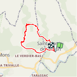

Length
6.9 km

Max alt
695 m

Uphill gradient
522 m
Km-Effort
13.9 km

Min alt
201 m

Downhill gradient
519 m
Boucle
Yes
Creation date :
2019-05-15 13:11:21.198
Updated on :
2019-05-15 13:11:21.254
2h52
Difficulty : Difficult

FREE GPS app for hiking
 SityTrail
IGN / Geographical institutes
SityTrail Plus
The world is yours!
About
Trail Walking of 6.9 km to be discovered at Occitania, Hérault, Saint-Martin-de-l'Arçon. This trail is proposed by CANON2.
Positioning
Country:
France
Region :
Occitania
Department/Province :
Hérault
Municipality :
Saint-Martin-de-l'Arçon
Location:
Unknown
Start:(Dec)
Start:(UTM)
498862 ; 4824391 (31T) N.
Comments