


ORLEANS - 200 bornes en 1977

norihtom
User
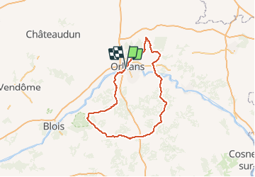

Length
194 km

Max alt
154 m

Uphill gradient
1481 m
Km-Effort
214 km

Min alt
79 m

Downhill gradient
1482 m
Boucle
Yes
Creation date :
2014-12-10 00:00:00.0
Updated on :
2014-12-10 00:00:00.0
--
Difficulty : Unknown

FREE GPS app for hiking
 SityTrail
IGN / Geographical institutes
SityTrail Plus
The world is yours!
About
Trail Cycle of 194 km to be discovered at Centre-Loire Valley, Loiret, Orléans. This trail is proposed by norihtom.
Positioning
Country:
France
Region :
Centre-Loire Valley
Department/Province :
Loiret
Municipality :
Orléans
Location:
Unknown
Start:(Dec)
Start:(UTM)
417374 ; 5304451 (31T) N.
Comments