


Four razerel

tomguerraz
User
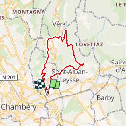

Length
11.9 km

Max alt
747 m

Uphill gradient
489 m
Km-Effort
18.5 km

Min alt
280 m

Downhill gradient
488 m
Boucle
Yes
Creation date :
2014-12-10 00:00:00.0
Updated on :
2014-12-10 00:00:00.0
1h23
Difficulty : Unknown

FREE GPS app for hiking
 SityTrail
IGN / Geographical institutes
SityTrail Plus
The world is yours!
About
Trail Running of 11.9 km to be discovered at Auvergne-Rhône-Alpes, Savoy, Bassens. This trail is proposed by tomguerraz.
Positioning
Country:
France
Region :
Auvergne-Rhône-Alpes
Department/Province :
Savoy
Municipality :
Bassens
Location:
Unknown
Start:(Dec)
Start:(UTM)
729450 ; 5050697 (31T) N.
Comments