Trail Walking Fontaine-de-Vaucluse - Fontaine de Vaucluse - Photo
© OpenStreetMap contributors
Length
Length
7.2 km
Max alt
Max alt
561 m
Uphill gradient
Uphill gradient
617 m
Km-Effort
Km-Effort  
15.2 km
Min alt
Min alt
80 m
Downhill gradient
Downhill gradient
524 m
Boucle
Boucle
No
Creation date :
2014-12-10 00:00:00.0
Updated on :
2014-12-10 00:00:00.0

(0 Reviews)

Walking
Walking
3h01
Difficulty : Difficult

Scan this QR Code to open this trail in the SityTrail application

FREE GPS app for hiking

Logo SityTrail SityTrail

IGN / Geographical institutes

Download SityTrail from the App Store Download SityTrail from Google Play

Logo SityTrail SityTrail Plus

The world is yours!

Download SityTrail from the App Store Download SityTrail from Google Play Download SityTrail on Huawei AppGallery

About

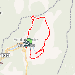
Trail Walking of 7.2 km to be discovered at Provence-Alpes-Côte d'Azur, Vaucluse, Fontaine-de-Vaucluse. This trail is proposed by MarcLEBARON.

Description

Boucle permettant l'accès à la Fontaine de Vaucluse vue du haut de la falaise.
La partie "aller" de la cote 342 à 574 est raide... ensuite chemin sur crête très agréable avant d'arriver au point de vue sur la fontaine. Retour par le vallon de l'Oule et château (manque un petit bout sur tracé).

Elevation profile

Positioning

Country:
France
Region :
Provence-Alpes-Côte d'Azur
Department/Province :
Vaucluse
Municipality :
Fontaine-de-Vaucluse
Location:
Unknown
Start:(UTM)
670741 ; 4865175 (31T) N.


Close
My subscriptions